it may be defined as the process of supplying water to soil for rising crops. other definition, it is defined as the application of water to soil for supplying the moisture essential for plant growth.
Factor affecting irrigation efficiency:
irregular land surface.
shallow soils underlain by gravels of light permeability.
long irrigation run.
steep slope of land surface.
compact impervious soil.
non-attendance of water during irrigation etc.
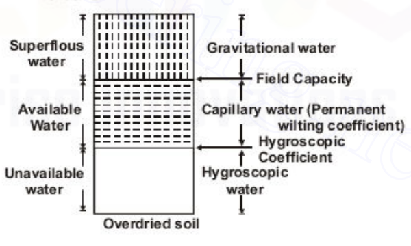
Water Present in soil:
Capillary water: is the part of excess hygroscopic water which exists in the pore spaces of the soil by molecular attraction.
Gravitational water: is that part of excess of hygroscopic and capillary water which will move out of the soil if favorable drainage provided.
Hygroscopic water: when oven dried sample is kept in the atmosphere, it absorbs some amount of moisture from the atmosphere, called hygroscopic water and it is not capable of movement by the action of gravity or capillary forces.
Duty (D) and Delta (Δ):
Duty: irrigation capacity of a unit water, or it is the area irrigated in hectares by 1 cumec of discharge flowing throughout the base period [hect/cumec].
Delta: it is the total depth of water required by a crop during the entire period, the crop is in the field (cm or m).
Relation between duty and delta: let ‘Δ’ in meter and ‘D’ in hectors which requires one cumec water for ‘B’ days; Δ = 8.64 B / D (m).
Factor affecting duty:
method and system of irrigation.
mode of applying water.
method of cultivation.
time and frequency of tilling.
types of crop.
base period of crop.
climate condition of the area.
quality of waters.
character of soil and sub-soil.
canal condition etc.
Method of improving Duty:
suitable method of applying water to the crop should be used.
Land should be properly ploughed and levelled before sowing the crop.
land should be cultivated frequently since frequent cultivation reduces loss of moisture.
reduce seepage, percolation losses and evaporation losses in canal should be required.
source of water should be good quality of water etc.
Base Period (B) and Crop Period:
Base Period: is the time interval in days between first water given prior to sowing and the last watering before harvesting (days).
Crop Period: it is the time interval between sowing and harvesting of crop (days).
Notes: 1. Saturation capacity: also known as maximum holding capacity or total capacity. it is the amount of water required to fill all the pores spaces between soil particles by replacing all air held in pore spaces. unit is equivalent cm of water per meter of soil depth. 2. Field Capacity: it is the moisture content of the soil after free drainage has removed most of the gravity water. Field Capacity = weight of water retained / dry weight of water. 3. permanent wilting point: also known as wilting coefficient. it is the water content at which plants can no longer extract sufficient water from the soil for its growth. it depends upon amount of silt in the soil. 4. Soil moisture deficiency: also known as field moisture deficiency. it is the water required to bring the soil moisture content of the soil to its field capacity. 5. readily available water: is the portion of available moisture that is most easily extracted by plants and approx 75% of the available moisture. 6. moisture equivalent: is an artificial moisture property of the soil used as index of the natural properties. Usually for a period of 30 minutes, Moisture equivalent ≈ field capacity or 1.8 to 2 permanent wilting point or 2.7 hygroscopic water. it is the percentage of moisture retained in a small sample of wet soil 1 cm deep when subjected to a centrifugal force 1000 times as great as gravity.
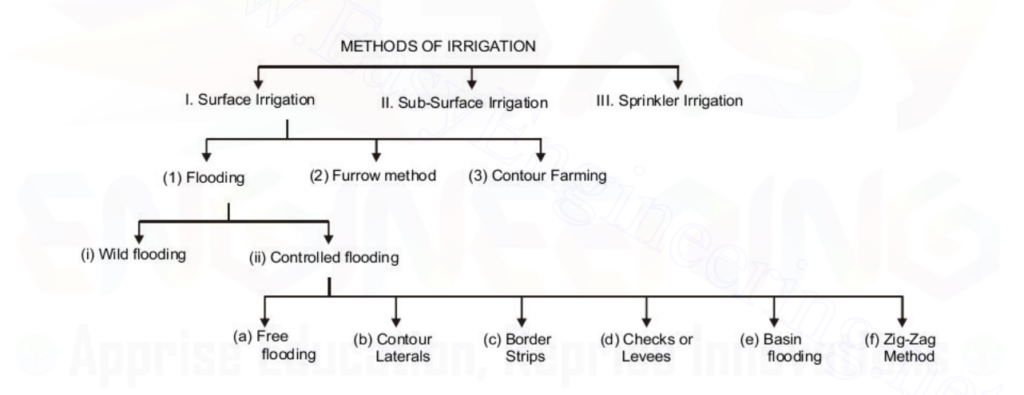
Types of irrigation:
surface irrigation: further classified into;
flow irrigation: in this type, the supply of irrigation water available is at such level that it is covered on to land by gravity flow.
lift irrigation: in this type, the water is lifted up by mechanical means. eg, water from well to irrigate.
perennial irrigation: constant and continuous water supply is done to crops through crop period. when perennial system of irrigation is done by canal system, called ‘direct irrigation‘ and done by storage reservoir, called ‘ storage irrigation‘.
flood irrigation: in this types, soil is kept submerged and flooded with water. moisture soaleed with occasional supplement of natural rainfall brings crop to maturity.
sub-surface irrigation: further classified as;
natural sub-surface irrigation: water leaked from channel causes rise in water table, which in turn provides water to crops through capillarity is termed as natural sub-surface irrigation.
artificial sub-surface irrigation: when a system of open jointed drain is artificially laid below soil, so as to supply water to crops by capillarity, known as artificial sub-surface irrigation.
Methods of Irrigation:
1. surface Irrigation:
Flooding:
wild flooding: in this method, water is spread on smooth flat land without much control or prior preparation. it is used in undulation system of land.
control flooding: water is spread on smooth flat land with proper method to control depth of application.
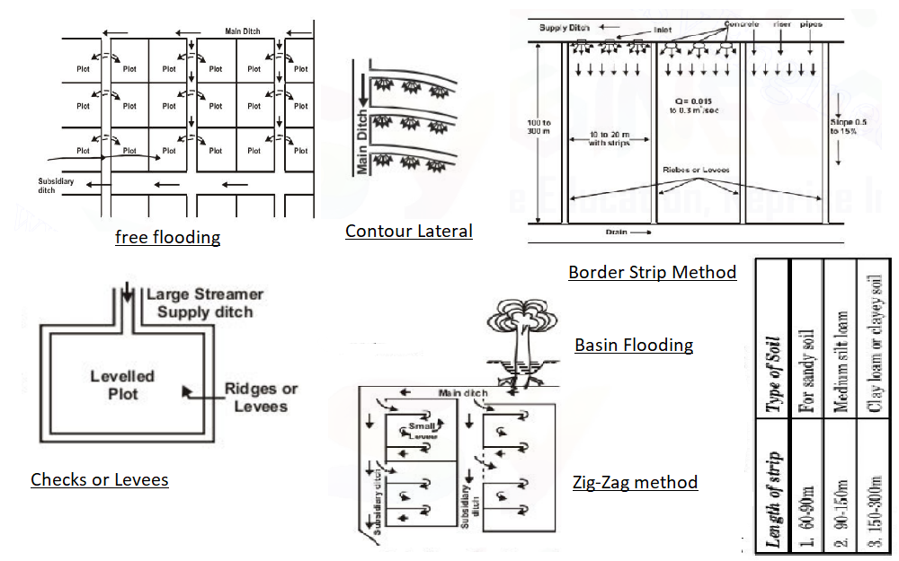
free flooding: fields are divided into an number of small sized plot which are in level. water is admitted at a higher end and supply cutoff lower part of plot.
contour laterals:- this method is used in steeper field. the field is cut by desne network of small contour lateral. spacing depends ongrade of field, soil and slope.
border strip method: this method is suitable for forage crop. farm is divided into series of strip (10-20m wide and 100-300 m long). advantage (low investment, high irrigation efficiency, lowest labour required and larger area can be irrigated within short time etc.).
checks or levees: a large stream discharges water into relatively level plot surrounded by checks or levees. this method is suitable for previous and impervious soils.
basin flooding: this method is used in garden or adopted to orchards. basin are formed for each tree. water is supplied to these basin through supply ditches.
zig-zag method: in this method, whole area is divided into number of square or rectangular plots. each plot is then sub-divided with the help of levees. this method is suitable for relatively level plot.
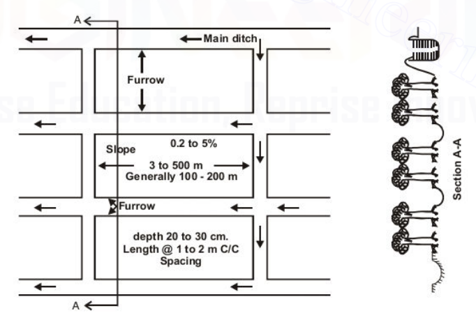
Furrow irrigation: this method is very much used for raw crops like maize, jowar, sugarcane, cotton, tobacco, groundnut, potatoes etc. furrow consists of a narrow ditch between rows of plot. furrows are sometimes made before planting. advantages (evaporation losses, low labour required, earlier cultivation is possible in heavy soil, no wastage of land in field for irrigation structure, suited for crops which may be injured by contact with water.)
Contour farming: it is used in hilly areas having steep slopes with quickly falling contours. the area is divided into longitudinal plots, bends of the plots follow the contours. first contour should be laid about 1.2 to 1.5 m vertically below the top of the hill. the irrigation water stored in some depression higher up.
2. Sub-surface irrigation:
water is supplied directly to the root zone of crop. water flows at a slow rate and seeps into the ground to maintain water table at a height such that water from the capillary fringe is available to the crop. Favorable condition (impervious sub soil, permeable soil in the root zone of soil, uniform topographic condition, good quality irrigation water).
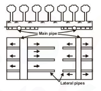
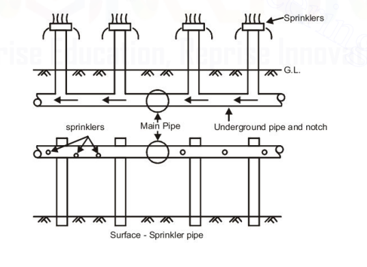
3. Sprinkle Irrigation:
in this method water is applied in the form of spray like ordinary rain.
this method is used where surface irrigation method is not efficient.
a pump lifts the water from the source, pushes it through the distribution system and through the nozzle.
useful for:
slope are excessive.
soil is erosive.
soil is excessive permeable or impermeable.
topography is irregular etc.
advantages:
erosion can be controlled.
uniform application of water is possible.
irrigation is better controlled.
irrigation efficiency is high.
eliminates deep percolation losses etc.
limitation:
wind may distort sprinkling pattern.
initial investment is high.
the power requirement is high.
water must be clean and free from sand etc.
Some important terms:
kor depth: it is the depth of water applying in first watering which is given to a crop.
kor period: it is the portion of the base period in which kor watering is needed.
paleo irrigation: at times of sowing crops particularly Rabi crops, land is very dry and needs to be moistened to help in sowing of crops, irrigation carried out for this purpose is called paleo irrigation.
root zone depth: it is the maximum depth in soil strata in which the crop spreads its roots system and derives water from the soil.
outlet discharge factor: the duty at the head of water course (at outlet point of minor) is called ‘outlet discharge factor.
cumec day: quality of water flowing for one day at the rate of perpendicular cumec. (=8.64 hectare meter)
time factor = number of days canal actually run / number of days of irrigated period.
capacity factor = mean supply (average discharge) / full supply of a canal
duty on capacity = area estimated to be irrigated during base period / design full supply discharge of channel at its head during maximum demand.
nominal duty = area of which permit has been granted for the period / mean supply for the base period.
Permanent wilting point = the moisture content of soil below which plants can’t extract sufficient water for their growth is called permanent wilting point. it is also known as wilting coefficient.
photosynthesis = it is the process of preparation of food by plants in the presence of sun light with the help of mineral, chlorophy II (present in leaves) and water.
transpiration = it is the process by which plants dissipate water from the surface of their leaves, stalks and trunks in the process of its growth. ratio of the weight of water transpirated by a plant during its growth to the weight of dry matter produced by plant exclusive of roots is called transpiration ratio.
open discharge = number of cumec days / number if days the canal has actually been used.
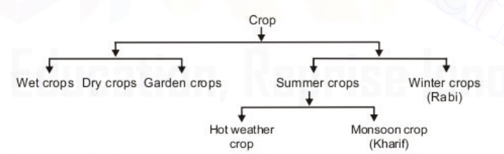
Principle crops:
Kharif crops: these are sown by the beginning of south west monsoon and are harvested in autumn.
Rabi crops: these are sown in autumn and are harvested in spring.
Wet crop: these requires water for irrigation.
Dry Crop: these doe snot require water for irrigation.
Garden crops: these requires irrigation throughout the year.
Some important terms:
crop rotation: it defines that nature of crop sown in a particular field is changed year after year.
crop ratio: area irrigated in Rabi season / area irrigated in Kharif season.
gross commanded area (G.C.A): it is the total area, bounded within the irrigation boundary of project, which can be economically without considering limitation of the quantity of available water. it includes cultivable and non-cultivable area as well.
culturable commanded area (C.C.A): it is the part of G.C.A, on which cultivation is possible. all of this area may not be sown or cultivated at a time.
unculturable area: it is the unfertile barren land, alkaline soil, local ponds, village and other areas as habitation.
intensity of irrigation (I.I): it is defined as ratio of actually irrigated area during a crop season to net cultivable commanded area.
Note: 1. In Strainer tube well flow is radial and mostly used in Nepal. 2. water jet boring method is used for soft soil. 3. percussion method of drilling is used for hard soil. 4. hydraulic rotary ( cable tool) method is used for unconsolidated soil. 5. the records of the sub-surface investigations and provide useful information about the material occurring at a various depths below the ground surface is called Logs. 6. the maximum quantity of water that can be supplied from the reservoir with full grantee, during the worst dry period, is known as safe yield. 7. the process of removing fine material from the aquifer formation surrounding the strainer pipe is called well development. it is done for increasing the capacity of tube well, preventing sand flow, to increase the life of tube well etc. method of well developments are pumping, surging, by compressed air, by back washing, by dry ice etc. 8. the process of interposing coarse material such as gravel and coarse sand between the well pipe and the aquifer soil to prevent fine particles of soil coming in contact is said to be well shrouding. 9. the mean velocity of the channel should never be less than critical velocity.
Design of channels:
stable or regime channels:
for proper functioning channel, it is designated such that neither silting nor scouring take place, such channels are called stable channels or regime channels.
a channel is said to be in the state of ‘Regime’ if flow is such that ‘silting and scouring‘ need no special attention.
Kennedy’s Theory:
What is Kennedy’s Silt Theory?
The theory says that, “the silt carried by flowing water in a channel is kept in suspension by the eddy current rising to the surface. The vertical component of the eddy current tries to move sediment up whereas sediment weight tries to bring it down. Therefore, if adequate velocity available to create eddies so as to keep the sediment just in suspension silting will be prevented”.
Assumptions regarding Kennedy’s Silt Theory
The eddy current is generated because of friction between flowing water and the roughness of the canal bed.
The quality of the suspended silt is proportional to bed width.
The theory is applicable to those channels which are flowing through the bed consisting of sandy silt or same grade of silt.
Critical velocity based on Kennedy’s Silt Theory
critical velocity is the mean velocity which will just make the channel free from silting and scouring. The velocity is based on the depth of the water in the channel. The general form of critical velocity is as follow:
Vo = CDn ……….(i)
Where Vo = Critical velocity D = full supply depth & Constants which found to be 0.546 and 0.64, respectively. Thus, Equation 1 rewritten as follow:
Vo = 0.546xD0.64 ……….(ii)
Moreover, Equation 2 further improved upon realization that silt grade influences critical velocity. So, a factor termed as critical velocity ratio introduced and the equation became as follows:
V = 0.546xmD0.64 ……….(iii)
Where m: critical velocity ratio which equal to actual velocity (V) divided by critical velocity (Vo), value of m provided in Table. Values of m based on the type of silt
Channel lining
N values
Earth
0.0225
Masonry
0.02
Concrete
0.013 to 0.018
Limitations of Kennedy’s Silt Theory
Trial and error method used for the canal design using Kennedy’s Silt Theory.
There is no equation for bed slope assessment, so the equation developed by Kutter used to compute bed slope.
The ratio of channel width (B) to its depth (D) has no significance in Kennedy’s Silt Theory.
There is not perfect definition for salt grade and salt charge.
Complex phenomenon of silt transportation is not fully accounted and only critical velocity ratio (m) concept is considered sufficient.
Lacey’s Theory:
Lacey stated that “a channel may not be in regime condition even if it is flowing with non-scouring and non-silting velocity”. Therefore, he distinguished three regime conditions as follows :
True regime: A channel is said to be in regime condition if it is transporting water and sediment in equilibrium such that there is neither silting nor scouring of the channel
the channel should satisfy the following conditions to be in regime condition:
Canal discharge should be constant.
The channel should flow through incoherent alluvium soil, which can be scoured as easily as it can be deposited and this sediment should be of the same grade as is transported.
Silt grade should be constant.
Silt charge, which is the minimum transported load should be constant.
If the above conditions are satisfied, then the channel is said to be in true regime condition.
Initial Regime: A channel is said to be in initial regime condition when only the bed slope of channel gets affected by silting and scouring and other parameters are independent even in non-silting and non-scouring velocity condition. It may be due to the absence of incoherent alluvium. According to Lacey’s, regime theory is not applicable to initial regime condition.
Final Regime: If the channel parameters such as sides, bed slope, depth etc. are changing according to the flow rate and silt grade then it is said to be in final regime condition.
Canal design using Lacey’s Silt Theory
Canal discharge (Q) and mean particle size (dm) should be known.
From the mean size or diameter of the particle (dm), silt factor is first calculated using the below expression :
silt factor (f) = 1.76 √dm
Velocity of flow (v) = {Qf2/140}1/6
Hydraulics mean depth (R) = 5V2/2f
wetted perimeter (P) = 4.75 √Q
Bed slope (S) = f5/3/3340xQ1/6
Drawbacks of Lacey’s Silt Theory
Lacey did not explain the properties that govern the alluvial channel.
In general, flow is different at bed and sides of the channel which requires two different silt factors but Lacey derived only one silt factor.
The semi-elliptical shape proposed by Lacey as the ideal shape of the channel is not convincing.
Lacey did not consider the silt concentration in his equations.
Attrition of silt particles is ignored by Lacey.
Lacey did not give proper definitions for the silt grade and silt charge.
Note: 1. Berm = it is the narrow width of land left at the G.L between the inner toe of the bank & top edge of the cutting. 2.back berm or counter berm = it is a horizontal benching provided on the outer slope to maintain sufficient cover over saturation line even bank embankment width is sufficient. 3.borrow pit = when the E/W is filling exceeds the E/W in excavation, then the pit which are dug for bringing earth, are known as borrow pit. 4.critical velocity = it is defined as the velocity where neither scouring nor silting occurs is known as critical velocity. 5.dowla = it is a structure provided on the bank of canal for the safety of automobiles during inspection of canal. it is provided on the side of roadway towards the canal. width vary 0.3 to 0.6 and height 0.3 m above service road. also known as dowel. 6.free board = it is the difference between FSL and bank level which depends upon the capacity of the canal. the main purpose of free board is to keep the saturation gradient line below the top of bank. it depends upon the size of canal, water surface fluctuations, location of canal etc. 7.spoil bank = when the E/W in excavation exceeds E/W in filling, then the excess soil is disposed of normally parallel to the canal on the edge of embankment which is known spoil bank. 8. while designing the canals, Manning’s formula is used for uniform flow. it is given by V = 1/n R2/3 S1/2 , where, V = velocity (m/s), n = roughness coefficient, R = Hydraulic mean depth, S = Hydraulic gradient.
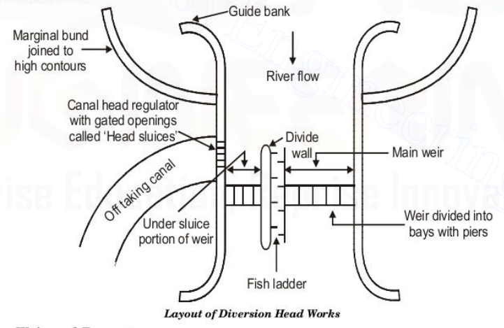
Diversion Head Works:
the work which are constructed at the head of the canal, in order to divert the river water toward the canal, so as to ensure a regulated continuous supply of silt-free water with a certain minimum head into the canal are called diversion head work.
1. Diversion weir and Barrage:
major part or entire ponding of water is achieved by a raised crest and a smaller part of it is achieved by the shutter, then this barrier is called weir.
diversion weir is a raised pucca structure with or without shutter and laid across the river width.
entire length of the weir is divided into a number of bays by means of divide piers so as to avoid cross-flow in floods.
most of the ponding is done by gates and a smaller or nil part of it is done by raised crest, then this barrier is called barrage or river regulator.
barrage gives less afflux and a better control upon the river flow because inflow and outflow can be controlled to a much greater extent by a suitable manipulation of its gates.
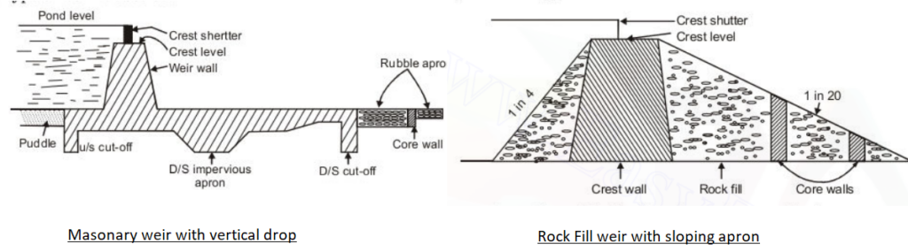
Types:
masonry weir with vertical drop: particularly suitable for hard clay and consolidated gravel foundation. however, this type of weir is obsolete.
rock-fill weir with sloping aprons: it is simplest type of construction and is suitable for fine sandy foundation like those in alluvial areas. however, with the development of concrete glasis weir, the above type also becomes obsolete.
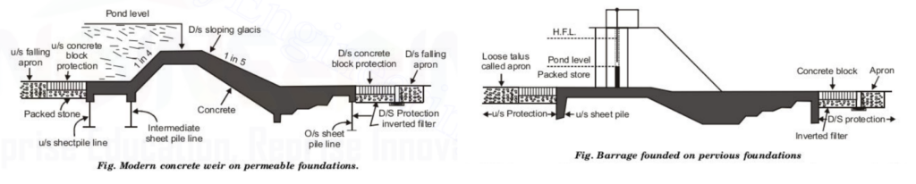
modern concrete weirs with sloping downstream glasis: this type of weir are exclusively used, especially on permeable foundations, and are generally provided with a low crest and counter balanced gates, thus making it a barrage.
Notes: 1. Afflux: rise in the maximum flood level (HFL) upstream of the weir, caused due to construction of the weir across the river is called afflux. 2. pond level: water level required in the under-sluice pocket upstream of the canal head regulator, so as to feed the canal with the full supply is called pond level. 3. Head regulator is provided in parent canal. 4. cross regulator is provided in branch canal.
2. Under sluices or scouring sluices:
these maintain a deep channel in front of the head regulator and dispose of heavy silt and a part flood discharges on the down stream side of the barrage.
function:
control the silt entry into the canal.
preserve a clear and defined river channel approaching the regulator.
scour the silt deposited in the river bed above the approach channel.
provide greater water way for floods, thus lowering the flood levels.
pass the low floods without dropping the shutter of the main weir.
3. Divide wall or Groyne/spur:
divide wall is a masonry or concrete wall constructed at right angle to the axis of the weir and separate the weir proper from ‘under-sluice’.
divide wall extends on the upstream side beyond the beginning of the canal head regulator, and on the downstream side, it extend up to the end of loose protection of the under-sluices.
function:
it separates ‘under sluice’ from the weir proper, since crest level of the under sluices is lower than that of the weir proper.
it helps in providing a comparatively less turbulent pocket near the canal head regulator, resulting in deposition of silt in this pocket and thus help in entry of silt free water into the canal.
Groynes are constructed transverse to the river flow and extended from the bank into river upto a limit. also known as spurs and transverse dikes.
repelling groynes (60° to 80° with upstream bank i.e 10° to 30° to the normal to the bank).
deflecting groynes (perpendicular to bank of river).
attracting groynes (45° to 60° with down stream side).
deheny’s groynes (T-shaped).
hockey groynes (Curved shape).
4. River Training Work:
these are required near the weir site in order to ensure a smooth and a axial flow of water and thus to prevent the river from outflanking.
river training works required on a canal headwork.
guide banks: it forces the river into a restricted channel.
marginal bunds: these are provided in the upstream side of the works in order to protect the area from submergence due to rise in HFL.
these are nothing but earthen embankment protected by groynes wherever needed.
5. Fish ladder:
it is a device by which flow energy can be dissipated in such a manner as to provide smooth flow at sufficiently low velocity not exceeding 3 to 3.5 m/s.
a structure which enables the fish to pass upstream is called fish ladder.
6. Canal Head Regulator or Head Sluices:
a head regulator may consists of a number of spans separated by piers and operated by gates similar to that provided in a barrage.
this is provided at the head of off-taking canal.
Function:
it regulates supply of water entering the canal.
it prevents entry of silt in to the canal.
it controls entry of silt in the canal.
7. Silt Control Devices:
the entry of silt into a canal which takes off from a head work can be reduced by constructing certain special work known as silt control work.
types of Silt Control devices:
silt excluder: is constructed on the bed of the river upstream of the canal head regulation. clear water enters the head regulator and silted water enters the silt excluder. in this types of work silt is removed from the water before it enters the canal.
silt ejector or silt extractors: extract silt from the canal water after silted water has travelled a certain distance in the off-taking canal. these works are constructed on the bed of the canal and a little distance downstream from the head regulator.
Canal Fall:
available natural ground slope is steeper than the designed bed slope of the canal then difference is adjusted by constructing a some short of structure called canal fall or drop.
function:
lowering of water level structure.
energy decipiation device.
protection of bed in downstream side.
types of fall:
ogee fall
rapid fall
stepped fall
vertical fall
sarada fall or special fall
Spillways:
it is a structure to divert excess water from upstream to downstream without causing any damage to the dam.
it is constructed at a dam side for effectively disposing of the dam surplus water from upstream to downstream.
a spillway can be located either within the body of the dam or at one end of it or entirely away from it.
requirements:
section of spillway should be economical.
it should be provide structural stability to the dam under all conditions of floods.
it should ne able to pass the designated flood without raising the reservoir level above H.F.L.
Water Logging:
an agricultural land is said to be water logged when its productivity gets affected by the high water table.
free water may rise above the surface of land making the cultivation operations impossible. such land is called swampy land (ordinary language).
problems created by water-logging:
normal cultivation operations such as tilling, plotting etc cannot be easily carried out in wet soils.
certain water loving plants like grass, weeds etc grow profusly and luxuriantly in water logged area thus affecting and interfering with the growth of the crop.
water logging leads to salinity.
causes of water logging:
over and intensive irrigation.
seepage of water from the adjoining high lands.
seepage of water through the canal.
impervious obstruction.
inadequate surface drainage.
excessive rain etc.
Water logging Control:
lining of canals and water courses.
reduce intensity of irrigation.
introducing crop rotation.
optimum use of water.
providing intercepting drain.
improving the natural drainage system etc.
Drainage and Types of drainage:
while designing a canal irrigation network, it is sometimes desirable to provide a suitable drainage system, so as to remove the excessive water.
1. surface drainage or open drainage:
it is the removal of excessive water by using and constructing open ditches, field drains, land grading and related structure.
2. sub-surface drainage or tile drainage:
sub-surface drain are required for soils with poor internal drainage and a high water table.
s.n
Types of cross drainage
Defination
1.
aqueduct
when the canal flow over the drainage then it is called aqueduct.
2.
Syphon Aqueduct
when the canal flow over the drainage but fully supply water level of drainage touches the bed of canal.
3.
Super Passage
when the natural drainage flow over the canal then it is called super passage.
4.
Canal Siphon
when the natural drainage flow over the canal and full supply water level of canal is much above the bed level of the drainage.
5.
Level Crossing
it is constructed in the circumstance when the beds of the canal and drainage are piratically meet at the same level.
Drainage Coefficient (D.C):
the rate at which the water is removed by a drain is called drainage coefficient.
it is expressed as the depth of water in cm. or meters, to be removed in 24 hours from the drainage area.
drainage coefficient depends upon rainfall varies with types of soil, types of crop and degree of surface drainage etc.
Method of Discharge and velocity Measurement
Discharge Measurement
Velocity Measurement
1. area velocity method
1. surface float method
2. weir method
2. sub surface float method
3. chemical method
3. pitot tube method
4. meter flume method
4. current meter method
5. stage discharge curve method
5. velocity method & twin float method
Quality related terms
Alkaline soil: the phenomenon of salts coming up in the solution and forming a layer of crust on the surface, after evaporation of water is called efflorescence. land effected by effervescence is called alkaline soil
Leaching: the process of removing alkali salt present in the soil (by flooding method) is called leaching.
Reclamation: it is the process by which an unculturable land is made fit for cultivation is called reclamation.
Salinization: it is the process of increasing the salt content is called salinization.
CIVILBOSS is a free education & learning platform, for the global community of civil engineering students and working professionals, where you can practice multiple choice questions & answers (MCQs), Study Notes, tutorials, Civil Engineering PSC Old Question for Various Level, PSC Exam Crack, Short Question & Answer for Related Particular Topicand Many More. It covers your one-stop destination for job exam preparation with daily practice MCQ and notes.
"Scientists dream about doing great things. Engineers do them."